

NAVIONICS Electronic Charts Updates MSD World
Original price was: $109.88.$86.81Current price is: $86.81.
- 100% environmentally friendly material
- 100% High Quality Guarantee
- Online assistance, always at your service.
- 7 days return and exchange

Navionics Updates World
- Choose your coverage area on line
- Marine and lake charts
- Contours up to 1 ft/0.5 m
- Daily updates
Get both saltwater and freshwater charts throughout the entire region chosen.
Download Nautical Chart, SonarChart™ 1 ft/0.5 m HD bathymetry map and Community Edits along with daily updates for one year! Simply plug your card into your PC/Mac to get the most updated charts from navionics.com. Choose from: Africa & Middle East; Australia & New Zealand; Baltic Sea; Caribbean & South America; Central & West Europe; China Sea & Japan; Greenland & Iceland; Indian Ocean & S. China Sea; Mediterranean & Black Sea; Norway; Pacific Islands; Russia West; Skagerrak & Kattegat; UK, Ireland & Holland; US & Canada. 2 GB card and USB reader included.
- Enhance SonarChart™ with sonar logs you collect using a plotter or mobile device.
- Includes one year of daily updates to Nautical Chart, SonarChart™ and Community Edits.
- Check compatibility at navionics.com, which is continuously updated.
View Chart Detail
Americas Compatibility Guide
EMEA APAC Compatibility Guide
| Card Type | Navionics |
|---|---|
| Cartography | World, Basemap |
| Type | Electronic, Charts |
Be the first to review “NAVIONICS Electronic Charts Updates MSD World”
Related products

Electronics & navigation
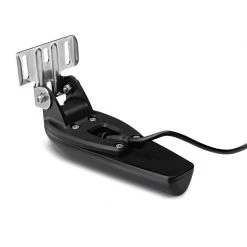
GARMIN Transducers GT23M-TM Transom Mount Traditional And CHIRP ClearVu Transducer
Electronics & navigation
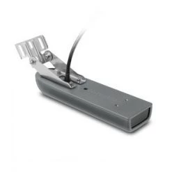
GARMIN Transducers GT21-TH Thru-Hull Traditional And CHIRP ClearVu Transducer
Electronics & navigation
Electronics & navigation
Electronics & navigation
Electronics & navigation

Electronics & navigation

Electronics & navigation
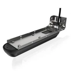
SIMRAD Transducers XSonic SS60 0° Tilt Thru-Hull Dual Frequency Transducer
Reviews
There are no reviews yet.